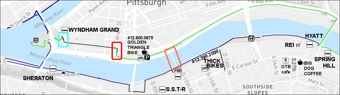
From where the actual GAP trail ends in Pittsburgh I believe on Grant Street to the end of the GAP at the point are there any bike lanes on the streets or does the cyclist simply need to share the road.
I have ridden in Pittsburgh but not on those streets instead taking the Fort Pitt bridge via the sidewalk to the point.
pslates
2016-07-25 14:46:40
There are no designated bike lanes from the city end of the Eliza Furnace Trail (a.k.a. "jail trail", or GAP) down to the point. You have essentially two roads.
1) Fort Pitt Blvd, which does have a cycle path for the first block, down to Smithfield Street, but not beyond.
2) From the little dogleg of trail that takes you to the corner of Grant St and First Avenue, here's how I'd do it: Actually turn right on First Avenue for a few feet, then an immediate U-turn, so you are lined up properly for the signal at the corner. When you get the green, turn right onto Grant, but get in the left lane to make the left turn onto Blvd of the Allies. When you get the green there, take the lane on BoA. It's downhill, posted 25 and four lanes, so you should have no problems.
Anywhere there's four lanes, you are entitled to use the entire right lane, without apology. (In other words, ride safely: Don't hug the curb, and don't ride in any door zones.) Anyone desiring to go faster than you, that's what the passing lane is for.
stuinmccandless
2016-07-25 14:59:11
In 2017 we hope to see one (or some) of these get built:
- a separated bike lane, which will probably go from Smithfield-&-First to Stanwix, via Stanwix to Penn, and then via Penn to Point State Park.
- a switchback ramp connected the Smithfield Street bridge with the lower Mon Wharf trail.
-an upgrade to "Grant's Crossing" between the Jail Trail and the joint-use sidewalk to the Smithfield Street Bridge
For 2016, there is no "established" route, and so different good people have different preferences. There's a lot of ways to do it. Using the Ft.Pitt Bridge isn't bad at all, although it does put you out on streets for a few blocks - and two cyclists were hit on the detour last month.
Here's my preference for non-local / unfamiliar cyclists, which is based on using Blvd of the Allies - but this is just my bad opinion, and you know what they say about opinions.

Riding from Jail Trail to Point (inbound, as we say)
At Grant St, turn right on sidewalk and ride alongside PNC.
Cross First Ave, stay on Sidewalk.
Make a 2-step Copenhagen left - first cross BoA, then turn left and cross Grant.
Once you're on BoA beyond Grant, take the lane.
From the Point to Jail Trail (outbound)
From BoA, cross Grant St & enter sidewalk by the park.
Use the sidewalk to get to the flagpole & Jail Trail.
What I'm trying to avoid in this set of turns is leaving the cyclist stopped on Grant Street, with cars coming up behind them, as we saw in the recent fatality on Forbes.
But this is all just personal technique, and my response assumes a non-familiar transient cyclist. YMMV n'at.
More discussion: outbound, I'd much prefer BoA, Smithfield Street, to the joint-use sidewalk but it's a BusOnly lane in that direction, and the sidewalk builds up some people waiting for the bus. IMO Grant Street is just too complex (and at times too fast) for a transient cyclist arriving with a loaded bike, and that's why I opt to recommend the sidewalk.
vannever
2016-07-25 20:20:27
At yesterday's Bike Plan open house, Nina Chase of Riverlife said that Riverlife is redesigning the switchback ramp from the Smithfield St Bridge to the Mon Wharf and they expect construction to begin in 2017. A reason that the first attempt at soliciting bids went badly is that the original design would have required the ramp to be constructed from a barge. They're now attempting to simplify the design so construction can be done without a barge, and costs can be reduced.
paulheckbert
2016-07-26 13:01:31
PG has a news story, but the big picture (expected construction start in early 2017) sounds the same, so what's new here?
http://www.post-gazette.com/news/transportation/2016/09/06/Mon-Wharf-switchback-ramp-delayed-again/stories/201609050019
"For the second time, plans for a switchback ramp from the Smithfield Street Bridge to the Monongahela Wharf trail have been postponed so the project could be redesigned to lower the cost. The agency Riverlife had expected to begin the project in the spring, but bids for the work came in too high again, said Jay Sukernek, vice president and chief financial officer. Now, it is expected to begin next year. “We went out to bid and the bids came back higher than the funds at hand,” Mr. Sukernek said. “We had to make a round of tweaks to allow the cost of come down some.”
Riverlife plans to seek a new round of bids in October and award a contract in early December. That would give the contractor plenty of time to prepare for work during next year’s construction season."
paulheckbert
2016-09-06 09:45:52
Sorry, just got to this thread...
If I were going from the Point to the EFT, I would L onto Liberty, R on Stanwix, L on 4th then R on Grant. You end up with slower car traffic.
The lights allow you to get in the Grant left lane then L on First, getting you on the EFT. The Grant bit might seem sketchy but the light sequence makes it work for you.
This basically works if you're coming from the Penn Ave bikeway.
Of course powering up the BoA is fun, but the cars are corresponding more annoying.
ahlir
2016-09-06 20:39:11
I hate stanwix in it's current configuration. I've nearly been hit a few times by people switching lanes without looking or signaling.
I prefer to just take commonwealth place to blvd of the allies from the point to 2nd ave to the sidewalk by firstside park which takes you right to the trailhead.
Inbound from EFT. I cross the highway offramps at the end of the EFT with the pedestrian signal, using the shared use sidewalk to the smithfeild street bridge. I then insert myself in the front of the traffic queue going toward downtown off the bridge and make a left on to blvd of the allies, right on to commonwealth place, and left in to the park.
benzo
2016-09-09 09:51:22
HI everyone - in just over a week I'm heading down to Pittsburgh from Ontario, to cycle the GAP Trail.
I have two questions for Pittsburgh cyclists - I hope someone can help me out.
The first relates to this thread - basically... if I'm at the GAP trailhead in Point State Park... how do I get started on the GAP trail? There's a website called bikecando.com that has a map that makes it look like you're on a river-side, dedicated trail from the very get go, riding along the north bank of the Monongahela River until you cross at the Hot Metal Bridge.
But.. within this thread... and in some other places... I'm seeing something different being described, where you have to get on the streets for a while (Boulevard of the Allies) and then hook onto the trail somewhere later.
So... first question.. how do I get started on the GAP trail from Point State Park? (PS I'm hauling a two-wheeled cargo trailer, if that factors into anyone's advice).
Second Question!
The night before I start riding the GAP trail, I'll probably have some time to kill, and wouldn't mind seeing Pittsburgh by bike. Anyone have a roughly 10 mile ride recommendation, that will let me see some of the sites, without duplicating what I'll be seeing on the GAP trail the next morning?
Thanks!
tucorides
2017-06-02 11:12:51
There's two basic ways.
You can get to the trail without any street riding at all by crossing the bridge across the Mon, using the sidewalk. Here's a link:
https://goo.gl/maps/m8ze3emgNnq. Some people don't like that because the sidewalk is kind of narrow with panniers.
The other way is to take streets up to the entrance of the Eliza Furnace Trail, like
this. Once you're on the trail you follow it up to the Hot Metal bridge, cross that, and turn left.
Either way works. Depending on when you're going, downtown traffic can be pretty minimal.
jonawebb
2017-06-02 11:28:04
Hi Jona - thanks very much for the info.
Well, the "cross the bridge immediately and ride on the south side" option looks easy.
I was looking at your google map... just before and after Liberty Bridge, is there a gap in the Three Rivers trail? It looks like there might be, if the map knows anything.
Otherwise the Three Rivers trail on the south side of the river will take me to the Hot Metal Bridge, where I'll start seeing GAP trail signage?
Thanks!
tucorides
2017-06-02 11:41:03
There's a gap in the trail near the Liberty Bridge but there's signs directing you around the gap. You have to ride on the street for a little bit and some of it is Polish block.
If you start on the south side of the river you don't have to cross the Hot Metal Bridge. You'll ride past it, on your left.
The GAP is an amalgam of different trails. You'll see signs for Three Rivers Heritage Trail, Steel Valley Heritage Trail, etc. It's all part of the GAP.
jonawebb
2017-06-02 11:45:12
Thanks Jona.
tucorides
2017-06-02 11:58:30
As to your second question, what to see. A couple of questions first.
1. Do you want company or just want to solo toodle around?
2. Will you be carrying your luggage, or will it be stored in a hotel room?
3. Do you want to stay on level surfaces and if not, how hilly is too hilly?
4. Would any of this include stopping somewhere for food or beverage?
5. Elapsed time and probable time of day limitations, if any?
I assume you have a solid, reliable lock, headlights, good brakes, etc.
Ideas that cross my mind:
a. Cross the Allegheny and sit for a few minutes in the Fred Rogers memorial. Best done solo. (Assumption: You are familiar with MisterRogers Neighborhood.)
b. Minus luggage, catch a 48 or 51 bus (US$2.50) and ride to the top of Arlington and South 18th St, just so you can coast down a 470-vertical-foot hill. Lots of food/beverage choices near the bottom of the hill along East Carson.
stuinmccandless
2017-06-02 12:31:08
Getting past the pinch points after the ft Pitt Bridge going toward station square is a pita on the best of days without a fully loaded bike.
I'd just head up on the streets, either Blvd of the alies or ft.pitt Blvd. It is short, traffic won't be bad.
edronline
2017-06-02 13:19:56
FWIW, get a bike map at pretty much any bike shop or the bike rental shop off 2nd ave if you're exploring. It will probably help a lot with wayfinding.
Digital options here:
http://localhost/resources/maps-guides-more/map-routes/
benzo
2017-06-02 13:20:29
Hi everyone - thanks again for all this advice.
Stu - I'd have stashed all my stuff at the hotel, so just toodling around unencumbered. The bus and long coast down the hill/mountain sounds good!
Edronline - you're thinking that the "cross immediately to the south side" option... while hauling a cargo trailer, is really tight? It'd be okay though if I dismounted, waited for other cyclists to pass, and inched by, wouldn't it?
I might have to just amble around on my "free" night before the ride starts and see what these intersections etc look like. I'm happy riding on streets (though not much experience doing it with a cargo trailer)... so if Boulevard of the Allies is fine, than no worries.
thanks again everyone.
tucorides
2017-06-02 15:17:03
BTW, this just showed up on the GAP Twitter account. It says the PawPaw tunnel is closed:
https://twitter.com/GAP_Trail/status/870721215585038337
And I wouldn't recommend the "immediately cross the Mon" option if you're pulling a trailer. The clearances are really tight. Better to ride on the streets, they're not bad.
jonawebb
2017-06-02 15:24:00
FWIW, starting some time this month, the Fred Rogers statute is supposed to be
blocked off for repairs. Even so, riding past that area and up the Chateau Trail offers some interesting sights (though if you're riding in the evening after it's gotten dark, I don't believe it's lit very well). You could visit the
Bicycle Museum in that area too, not far off the trail.
steven
2017-06-02 15:32:57
marko82
2017-06-02 15:34:04
Thanks Jona, for the Paw Paw note. i just saw that on Facebook as well. I'm only going to Cumberland, then turning around and biking north again. The Paw Paw looks like it is on the C & O south of Cumberland?
Marko - thanks for that route... looks like a nice loop that would indeed give me some idea what to do on "ride" morning.
PS - go Pens!
tucorides
2017-06-02 15:51:45
Yes, that's right.
jonawebb
2017-06-02 16:00:47
And, Ithink that this is the last weekend paw paw is open. They extended it being open for just this weekend.
And yes. Paw paw is about 30 miles from Cumberland on c and o.
Have fun with the out and back. I've done that before.
edronline
2017-06-02 16:44:56
Fred Rogers is mere feet off the path across from the Point. It'll either be open or not, so you may as well roll by and see what's what. Frankly you're going to have more trouble a couple hundred yards later with all the work around the Science Center. Which I mention because it's a worthy destination. The lower level is free, with an excellent bike rack, a decent restaurant, and modern restroom facilities just inside. But there's a lot of w ork on the river side so don't go there. Go around the other side, dismount at the street exit, and walk the bike the wrong way past the exit gate. (You can bike through the parking lot, too, going the proper way, and deal with lots more car and pedestrian traffic.)
I suggested coming down South 18th because it's really not all that steep, just very long. I roll about 27 mph, typically. OTOH, I can hit 45 coming down Federal Street, a scary, eye-watering plummet. Not for the unpracticed! Plus, Federal has rotten pavement, and a stop sign 3/4 of the way down. South 18th is just a long, easy glide. If you feel like biking up it, it'll take you about 20 minutes to save you the $2.50 bus fare, and you can have the bragging rights for having done so. (Biking up Federal is a leap of faith, even for the locals.)
Another way to experience the uniqueness of The 'Burgh is to carry your bike up a staircase. We have over 700 to choose from! Pretty darn sure you won't have to deal with any car traffic, and since you're using a different set of muscles, you won't wear yourself out trying to pedal up the hill. There exist some multi-hundred-step monsters, but there are hundreds of them in the two-digit range. Too many to suggest.
No, one suggested set of steps. Ever seen
Flashdance? The
opening scene starts at Catoma and Myler in the Fineview neighborhood, north of the river. To get up there, you'd use James St past Allegheny General Hospital (seen at 1:14 in that clip), but three sets of steps (165 total) get you up to Henderson St, most of the way there. There's also a nice overlook at Catoma and Meadville. Really nice view of the city from up there, hence the name, Fineview. But it is one hell of a climb. (Also note the impossibility of her bike commute, as it has her traveling south to north across the Smithfield St Bridge after passing the hospital.)
stuinmccandless
2017-06-02 22:09:54
And, Ithink that this is the last weekend paw paw is open. They extended it being open for just this weekend.
Then they unextended it, and closed it for safety reasons yesterday, June 2. Details
here and on the GAP Facebook page
here.
Should you wish to carry your bike up some stairs, there's a page covering lots of them
here. But in my view, carrying your bike up one of our many public steps is an
extremely optional part of the Pittsburgh cycling experience. :-)
steven
2017-06-03 00:40:43
Sorry folks, more questions. Thanks in advance for any insights.
My hotel is near Bates and Boulevard of the Allies, and I'm questioning how important it is for me to bike to Point State park with a cargo trailer first thing in the morning, to be able to say that I started the GAP trail at the trailhead.
So... my question is... what is Bates like to ride? The Pittsburgh bike map marks it as a Cautionary Bike Route... which handily seems to take me straight to the trail and almost immediately to the Hot metal Bridge.
But... google streetview makes it look like a congested nightmare.
Any opinions on riding Bates?
Thanks again.
tucorides
2017-06-06 15:42:55
I'm guessing you're starting out early in the morning. You shouldn't have a problem going downhill. All the traffic is going the other way. You can take the Eliza Furnace trail downtown from there (you don't need to cross the Hot Metal Bridge) to get to the point. Like this:
https://goo.gl/maps/cjJaA93iDZu
jonawebb
2017-06-06 16:10:17
I usually hop on the sidewalk at the bottom of bates and ride it toward downtown, then there is a ramp up to the eliza furnace trail off the sidewalk so you can avoid riding on the bike-unfriendly 2nd ave.
benzo
2017-06-07 09:17:10
This is what the bottom part of Bates looks like at night.
Start at the 6:10 point. Note my diversion onto the sidewalk before the traffic light at Bates and Second. You get to the ramp up to the trail at about 7:25.
The early part of the video is about riding somewhere entirely different (as the locals might guess, based on where I am at 6:10).
stuinmccandless
2017-06-07 10:09:20
Thanks Stu & Benzo.
Stu - I can tell (in your video) when you get onto the sidewalk along Bates, and then it looks like you make a sharp right turn and are on another sidewalk.
At that point... are you riding the sidewalk along side 2nd Street... heading west (briefly) towards Point State Park?
And then the video gets really dark and I can't really see the ramp you refer to... but somewhere up there (from the 2nd street sidewalk?) there's a ramp up to the Eliza Furnace Trail?
Thanks again everyone.
tucorides
2017-06-07 11:46:08
Yes. I'm on Bates. Hop on the sidewalk to go under the bridge (the trail, formerly a railroad), turn right onto the Second Avenue sidewalk, and stay on that sidewalk a couple hundred yards. You should have no trouble seeing the wooden ramp up to the trail, even if it's dark. Just a bit of caution, that there are a couple little wiggles to get on and off the ramp, it's narrower than the sidewalk, sight lines at the top of the ramp are not great, and chances are non-zero (though not high) of encountering fairly fast trail traffic.
stuinmccandless
2017-06-07 14:43:32
Stu, and everyone else - I went, I rode the GAP, and am now back in Canada.
Thanks very much for all the advice provided in this thread about the GAP trail through Pittsburgh.
Stu, thank you for the notes about Bates / 2nd Street / the ramp up to Eliza Furnace. That was exactly what I did in the end, and I never would have known about that connection if you hadn't mentioned it.
On my return trip back into Pittsburgh I did end up going right into Point State Park to find the trailhead.
Thanks again everyone!
tucorides
2017-06-19 12:15:03