@v, awesome!
2016-05-09 13:30:08
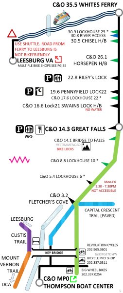
 it's different from the other offerings in these ways:
-uses the AAA-tripticket format
-uses a railroad-map-style to navigate the railroad-based-trail
-provides addresses and coords for support vehicle drivers
-identifies areas of low- or no-cell coverage (Verizon based)
-callouts for hazards
-drill-down maps for towns (lodging, food, camping, wifi)
-shows restrooms and porta-johns (they're different, after all)
-shows water, food, bike shops, bike tool workstations
-shows primary and alt-routes, including the DC W&OD transition
-labels "hi-scenic value" areas for folks not riding every single mile.
-links to a customized Google map showing the same info
GoldenTriangleBike.com will have them for sale on their website, probably later this week. But they're on sale right now at Golden Triangle.
Mods- if this isn't ok, I'm sorry - please delete. thanks!
it's different from the other offerings in these ways:
-uses the AAA-tripticket format
-uses a railroad-map-style to navigate the railroad-based-trail
-provides addresses and coords for support vehicle drivers
-identifies areas of low- or no-cell coverage (Verizon based)
-callouts for hazards
-drill-down maps for towns (lodging, food, camping, wifi)
-shows restrooms and porta-johns (they're different, after all)
-shows water, food, bike shops, bike tool workstations
-shows primary and alt-routes, including the DC W&OD transition
-labels "hi-scenic value" areas for folks not riding every single mile.
-links to a customized Google map showing the same info
GoldenTriangleBike.com will have them for sale on their website, probably later this week. But they're on sale right now at Golden Triangle.
Mods- if this isn't ok, I'm sorry - please delete. thanks!