BIKEPGH MESSAGE BOARD ARCHIVE

« Back to Archive
20

PennDOT Bike Route Map

"PennDOT releases interactive map to enhance bicycling experience" ~Pittsburgh Post-Gazette, May 16, 2016 4:31 PM In an effort to get more people bicycling and walking, several state agencies and the governor announced today the creation of an interactive map designed to assist people traveling within the state. 
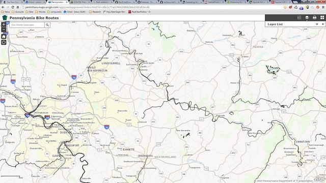
The Bike Route Map will provide detailed bike routes, traffic volumes and speed limits, according to a PennDOT release. It also will include trails maintained by the Department of Conservation and Natural Resources, state parks and state forests. The announcement was made in conjunction with Gov. Tom Wolf's Bike to Work Week. “With the many benefits of bicycling, I encourage Pennsylvanians to bike to work wherever possible,” Leslie S. Richards, the PennDOT secretary, said in the release. “Interest in biking continues to grow across Pennsylvania as more people recognize the benefits of incorporating active transportation, biking and walking into their lives. Our message today is that PennDOT and the commonwealth are committed to being truly multimodal.” The interactive map can be accessed at www.penndot.gov, then going to the “Travel in PA” listing and clicking on the “Ride A Bike” link. Officials also are using the map to promote safety and the health benefits of bicycling. “I encourage you to make the choice to commute to work by bike,” said Karen Murphy, the Department of Health secretary. “It can boost your physical wellbeing and provide an opportunity to de-stress and enjoy some fresh air.” The state says the new map will provide visitors with greater access to Pennsylvania's natural resources: "We are blessed with more than 11,000 miles of trails, 121 state parks and more than 2.2 million acres of state forest land, all offering unlimited biking terrain and opportunities," said Cindy Adams Dunn, the DCNR secretary. "Biking is one of the best activities to see what our very special outdoor places have to offer.” News article: http://www.post-gazette.com/life/recreation/2016/05/16/PennDOT-releases-interactive-map-to-enhance-bicycling-experience-in-Pa/stories/201605160135 Map: http://pennshare.maps.arcgis.com/apps/webappviewer/index.html?id=d8e1c77ad2444268bb56bd2d2a85ec46 It's a start - but I think PennDOT should consult BikePittsburgh when making the map. The PennDOT map is missing a lot of details compared to BikePittsburgh map, such as sharrows, bike lanes, bicycle-related services, and etc.
ninjaturtle0304
2016-05-16 22:53:30
Does penndot map only include penndot controlled roads?
edronline
2016-05-17 06:37:02
It shows all the roads but has useful info for the roads they control. It doesn't include bike trails or lanes etc. It's not a replacement for local bike maps or Google maps. But it is useful at least in showing the state bike routes in a more convenient form than they had earlier, and in identifying the speed limits and shoulder width on roads. I don't think that's available elsewhere.
jonawebb
2016-05-17 08:19:03
@JonaWebb: Actually, PennDOT map did have bike trails. You'll need to find the panel on the upper right corner, click on the "Layer List" icon, which is the second icon from the left. Next, uncheck all the layers except the "Explore PA Trails", and you should be able to see the bike trails shown below:
ninjaturtle0304
2016-05-17 08:41:05
@Gordon cool. There's also other useful stuff there, like traffic volumes. Wait, how current is that information? Can you really get from Pittsburgh to Johnstown on trails? PA trails
jonawebb
2016-05-17 08:44:11
Another potential way to use the PennDOT map is to check only the "Traffic Volumes" under the "Layer List" tab. Darker gray lines represent roads with heavier traffic - avoid them if possible.
ninjaturtle0304
2016-05-17 09:01:44
Can you really get from Pittsburgh to Johnstown on trails? Yes, as the map shows, you can. But perhaps this bike map should not include water trails. :-)
steven
2016-05-17 09:28:43
Oh baycycle-water-bike
jonawebb
2016-05-17 09:41:36
"Our message today is that PennDOT and the commonwealth are committed to being truly multimodal.” pfft. I'll believe that when I see it actually trickle down to the regional office bureaucrats.
edmonds59
2016-05-17 11:41:34
From PennDOT's press release. "For more information on bicycle safety, visit www.JustDrivePA.com." Maybe a new domain name would help with that multimodal message? I think MostlyDriveButBikeOrWalkALittleIfYouAbsolutelyMustPA.com is free.
steven
2016-05-17 12:18:28
I think MostlyDriveButBikeOrWalkALittleIfYouAbsolutelyMustPA.com is free. Laugh out loud.
mick
2016-05-17 12:58:41
It might be useful to have copies of... "With the many benefits of bicycling, I encourage Pennsylvanians to bike to work wherever possible. Interest in biking continues to grow across Pennsylvania as more people recognize the benefits of incorporating active transportation, biking and walking into their lives. Our message today is that PennDOT and the commonwealth are committed to being truly multimodal.” ...with you at the next PennDOT plan presentation, public meeting, etc. when asking for a greater level of bicycle/pedestrian accommodation be included as part of the project. If, ok when, they start to give excuses why this isn't possible for this project, you can explain to them that the above quote is from their boss.
offtn
2016-05-17 14:37:47
On rite S, what is the Pike to Bike section like. Description says "abandoned turnpike section and two turnpike tunnels.". Where exactly is this?
edronline
2016-05-17 21:13:07
Breezewood. From the west - head easton 30 past the turnpike area and look on your left for Tannery Road. Park just off 30 on Tannery and walk your bike up the dirt path. The A.T is pretty beat up. You'll need lights for the tunnels. If I remember correctly, it's 17 miles or so.
durishange
2016-05-18 10:41:34
The graphics on this PennDOT map are backward: * freeways and dangerous roads with fast, heavy traffic are bold; * safe roads with slow, light traffic are faint; * trails are thin lines, off by default; * they failed to mark Bicycle Route A (51) with skulls & crossbones. So it's best as a map of where not to bike.
paulheckbert
2016-05-21 05:22:31
From PennDOT’s press release. “For more information on bicycle safety, visit http://www.JustDrivePA.com. Maybe a new domain name would help with that multimodal message?
I just got a tweet that clears this up a little. JustDrive 
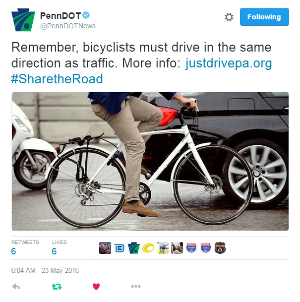
They think we drive bicycles (remember, they call their manual the "Bicycle Driver's Manual"). It's not common usage, but I guess it makes sense that whoever's controlling a vehicle is driving it.
jonawebb
2016-05-23 09:27:48
When Ms. Rosenblatt, the reporter, talked to me on the phone, I'm pretty sure I didn't say I "prefer roads where the speed limit is below 70 mph", as she quoted, but rather "... 35 mph".
paulheckbert
2016-05-25 14:53:20