A planning grant will help determine the best way to reconnect the areas
A recurring theme seen in Pittsburgh’s history of city planning and urban development has unfortunately been one of forced division. The highway-focused mentality of past local and state planners has caused harm to multiple communities across the Steel City. We’ve written a bit about the nationwide history of segregation by design already in this blog series – how primarily Black and low-income neighborhoods were razed to build modern highway systems – and Pittsburgh is no exception. Now, a federal grant aimed at reconnecting such neighborhoods is hoping to right the wrongs of the past.
But first: How did we get here?

For the past decade, residents in the Manchester neighborhood of Pittsburgh have been rallying for a reconnection with Chateau, a neighborhood forcibly created by the State during the construction of Route 65 (Ohio River Boulevard). A period commonly known as the ‘Pittsburgh Renaissance,’ beginning in 1946 and ending in 1973, saw large-scale urban redevelopment throughout the city, most notably downtown, the Hill District and Northside. One such project envisioned “industrial districts…created west of Chateau Street,” as well as “new highways [running] along Chateau Street,” according to Dan Rooney and Carol Peterson, authors of “Allegheny City: A History of Pittsburgh’s Northside.”
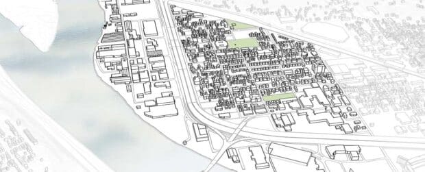
The proposed new highways running along Chateau Street would become what is now Route 65. Construction began in 1961, after the acquisition and demolition of multiple crossroads in the primarily-Black community that used to seamlessly connect the areas we now view as distinct neighborhoods. The highway became an unwanted border for the small area that is now Chateau, forcibly separating it from Manchester and creating a new neighborhood. With the highway splitting what was once a contiguous community, the population of the area dropped rapidly. By 1970, only 681 people still remained in Chateau.
Major funding win for reconnection planning
Last year a $1.4 million federal Department of Transportation grant was announced to begin the formal plan for the reconnection of the two neighborhoods. Allegheny County and Pittsburgh officials demonstrated clear support for the grant from the new Reconnecting Communities program created under President Biden’s Infrastructure Investment and Jobs Act.
“As we celebrate this investment — long overdue, by the way — it’s tempered by the reality of what happened here,” U.S. Sen. Bob Casey, D-Pa., said during a news conference announcing the grant award last March. “We’re here to bridge a divide. We’re also here to right a wrong that has existed for far too long.”
Former County Executive Rich Fitzgerald noted the highway was intended to “connect people from far away, but it ended up cutting off people close by.”
“The real reason to connect it again is the people,” said Mayor Ed Gainey. “It’s time we rebuild and connect things.” U.S. Rep. Summer Lee, D-Swissvale, didn’t mince any words and called construction of the highway “a case study in urban planning gone wrong.”

What does this mean for the residents and community?
With this movement towards reconnection, and increasing interest in the neighborhoods, comes challenges. Though new residents are beginning to be attracted to the area, some who have been there for years are worried about rising housing prices. They say it will be necessary for developers building or renovating in the area to balance the needs of the community – to encourage development without displacement. In addition, much of this area is underserved by local neighborhood-scale commercial uses.
The planning grant will help fund a $1.8 million feasibility study to determine the best way to reconnect the neighborhoods and direct investment towards the right projects. As LaShawn Burton-Faulk, executive director of Manchester Citizens, put it, the grant will allow the neighborhood to “confront our past mistakes and decisions.” These decisions continue to affect daily life – access to restaurants, personal and medical services end even groceries – because the loss of the commercial district during highway construction has never been remedied. The loss also extends to public green & open spaces in the neighborhood. To recreate a cohesive neighborhood identity, residents say, both the public spaces and commercial corridors must be re-established.

What’s next?
To learn more, or to learn how to get involved as a resident, make sure to check out more information on the City of Pittsburgh’s website about the Manchester-Chateau Neighborhood Plan.
The Plan calls for improvements for safe connections between Manchester, Chateau and the riverfront with green corridors, specifically along North Franklin Street and Columbus Avenue in Chateau and the Juniata intersection/Route 65 underpass, the only existing crossing between Manchester and Chateau. Turning these corridors into green, park-like streets will have significant environmental benefits as well. The current scope locations were developed by the Sustainability Action Team members during the final stages of development of the Manchester-Chateau Neighborhood Plan.
by BikePGH Staff Contributor – Kéya Joseph
1 Comment
This is great news! I think another important project would be to make a usable bike path across the west end bridge. You have to carry you bike up steps and there are minimal pedestrian walkways (on the west end side).