
Rightsizing: Maybe, just maybe, we don’t need so many lanes
Infrastructure Learning Series
Before there were bike lanes on Forbes Ave between Pitt and CMU, many believed that reallocating some of the lanes for bicycling would cause traffic chaos in the busy corridor. While BikePGH was consistently pushing for better cycling options between the universities, we got a surprising assist: a full road closure on Forbes Ave.
Road closures offer a natural experiment on how drivers behave after a change. They tend to simply change their route and disperse the congestion, while flummoxing those who deny the laws of induced demand. Even with a full road closure, the traffic chaos on Forbes never materialized, and in turn helped make the case that there was indeed excess capacity dedicated to motor vehicles. There seems to be a perception that cars “need” much more space than they already have (looking at you, West Carson St?), and that reallocating this space to other uses is untenable.
Rightsizing is the process of reallocating a street’s space to better serve its full range of users.
The reality is that Pittsburgh has shrunk in population and our commuting habits have changed significantly. According to the US Census, in 2015, about 64% of workers drove to their jobs. Today, that number’s at 54%, due in part to a shift to working from home. It turns out that in many cases, there’s actually too much space dedicated to cars, and that “rightsizing” our streets with bike lanes, bus lanes and wider sidewalks may be the best and most efficient way to transport people. The PRT’s BRT project is a prime example of reassessing the roadways to meet current demands on a large scale.
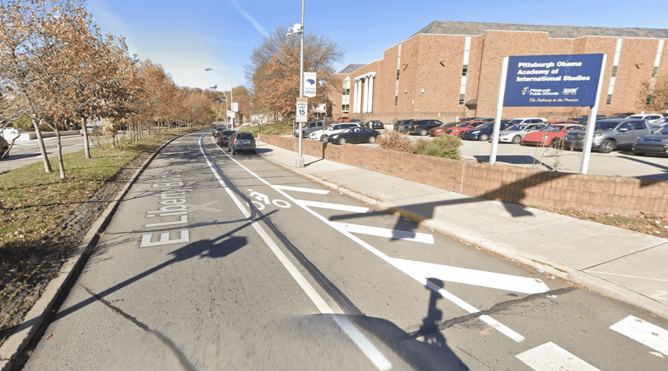
One of the original “complete streets” style rightsizing projects in Pittsburgh occurred in 2008 on East Liberty Blvd, where the four lane road was turned into two lanes, with two bike lanes and parking. At the time, traffic chaos was predicted, yet most people wouldn’t even know of the former layout, and would definitely not want to return to it.
So when a road closes in a major corridor, and it ends up not being all that big of a deal, it begs the question: Do we really need all this space dedicated to cars?
Take a look at this short list of places that are currently closed and have new bike infrastructure either on the way, in the planning phase, or are wishful thinking on our part. Considering it’s closed now, will a single lane permanently dedicated to safely moving people on bikes really be that big of a deal when they reopen?
Smallman St and Penn Ave, Strip District
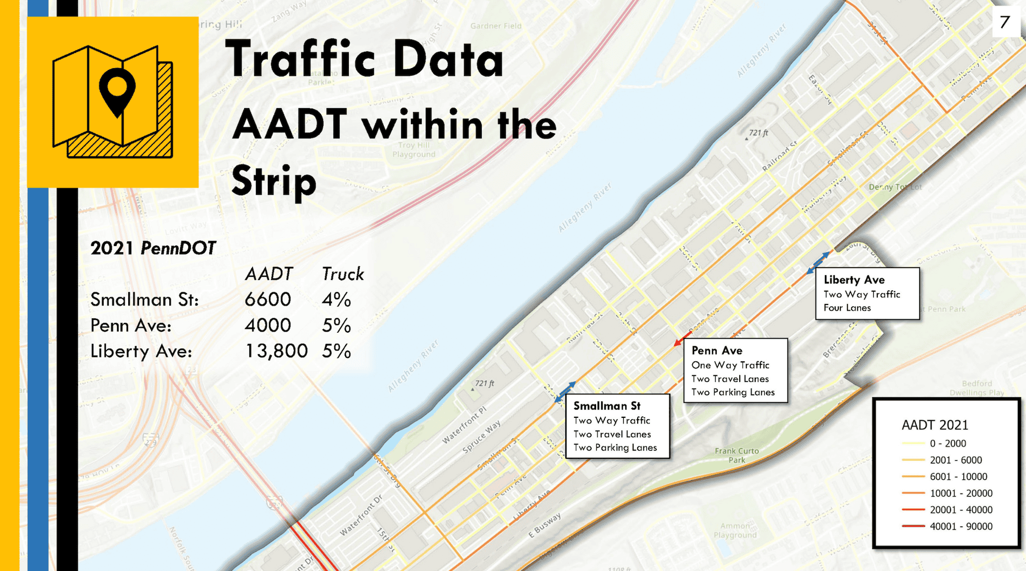
Smallman Street in the Strip District has been fully closed at 26th St for about a year: can anybody tell? There is not the noticeable increase in congestion that many predicted. Once reopened, even fewer drivers will be using Penn Ave to get through the neighborhood. Currently, there are 14 lanes dedicated to moving or parking cars through the Strip, and the closure shows that reallocating some space will have minimal impact on traffic and the perceived congestion. Enter two projects in the Strip.
The Penn Ave Right-Sizing Project aims to extend the single inbound lane on Penn from 31st to 22nd Street, and create a bike lane connecting the adjacent neighborhoods to all the goodies and job opportunities that the Strip has to offer.
A companion project to Penn Ave is the Smallman Street Complete Street. This project, while funded, is still in the planning phase. It aims to improve the sidewalk conditions that do exist, install sidewalks where they don’t, and introduce a bike lane for residents in the outbound direction to Lawrenceville.
Charles Anderson Bridge and Panther Hollow Bridge, Oakland
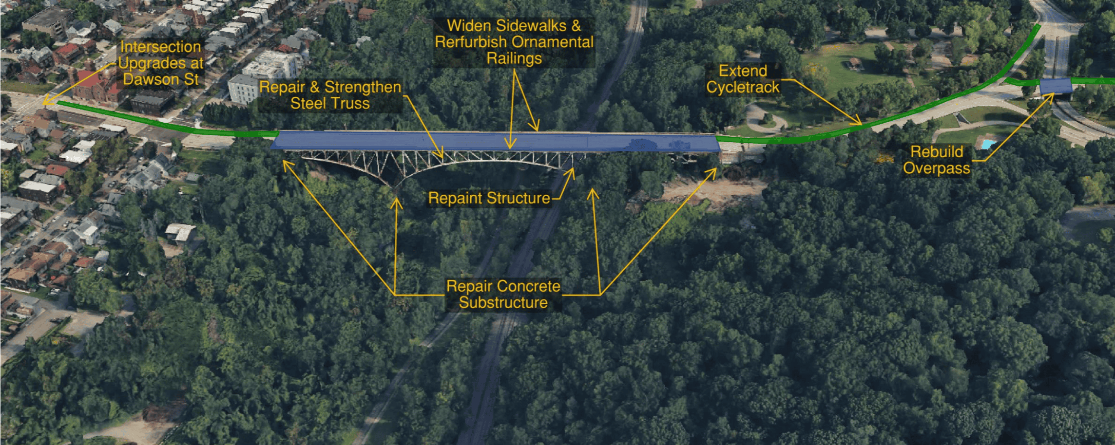
Unfortunately, the City was forced to close the Charles Anderson Bridge much earlier than expected. On the bright side, they are now planning to extend the Schenley Ave Bike Lanes across the new bridge into South Oakland.
The recent Charles Anderson Bridge and Panther Hollow Bridge closure, with the lack of expected congestion, proves that a lane dedicated to safely riding bikes will have minimal impact on the flow of motor vehicles.
We did lose an opportunity when the Greenfield Bridge was closed a few years ago to add bike lanes further up Panther Hollow Rd into Squirrel Hill and Schenley Park. Considering all the closures, we’re pretty confident that installing a bike lane into the park will work out just fine.
Neville/Boundary St, Oakland
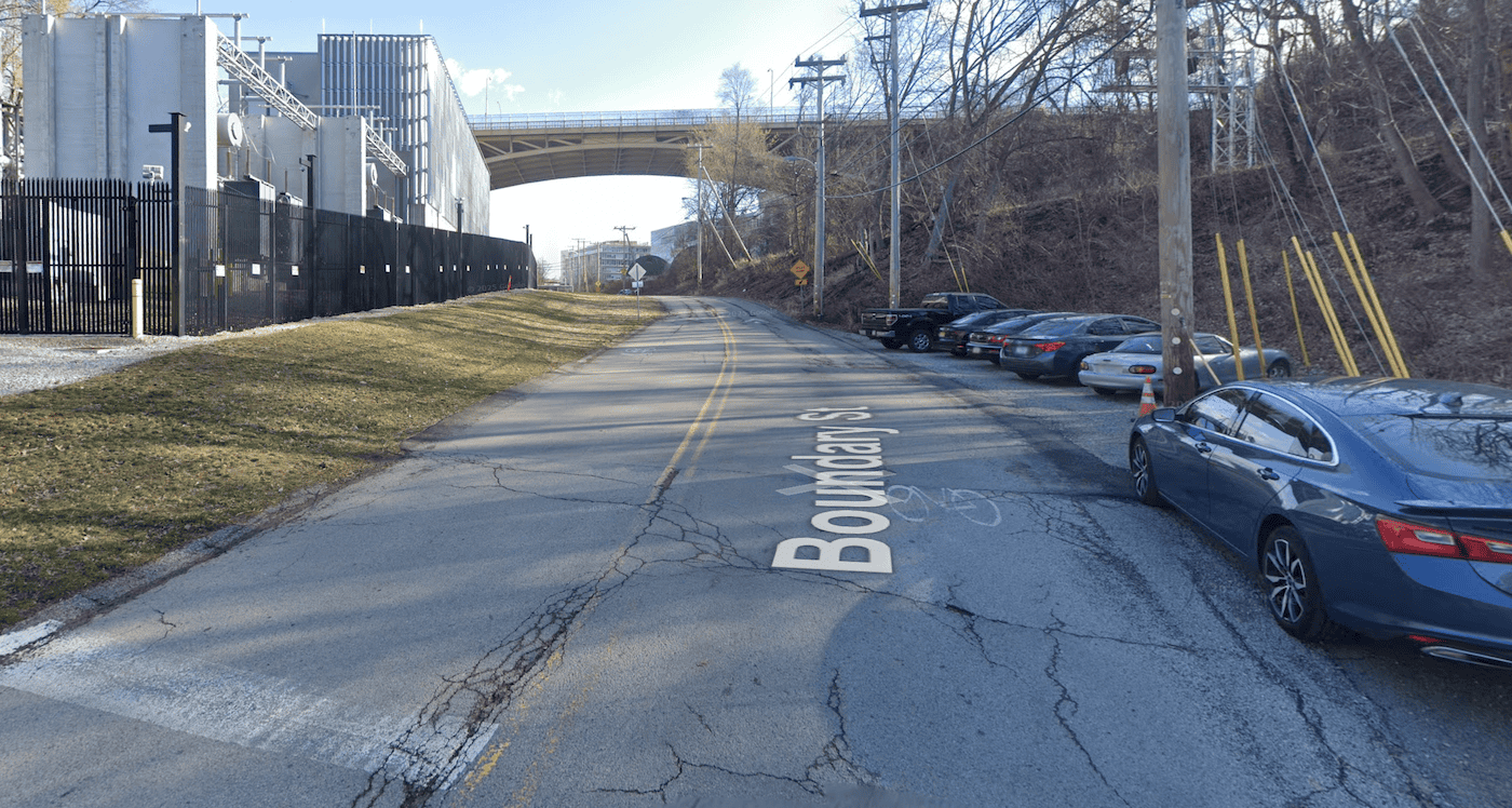
Neville and Boundary serve as the primary connection to and from the Junction Hollow Trail, and currently lacks sidewalks. Even with the traffic calming on the street, riders contend with fast moving traffic along with pedestrians, who don’t even have a sidewalk.
The road is currently closed to motor vehicles, but open to bikes and peds, offering the perfect experiment to see what reallocating some of the space will do.
While still in the planning phase, the City is looking to improve the corridor in the Boundary St /S Neville St. Streetscape Enhancement Plan for non-motorized transportation and to better connect to CMU and the trail.
Butler Street, Lawrenceville/Morningside
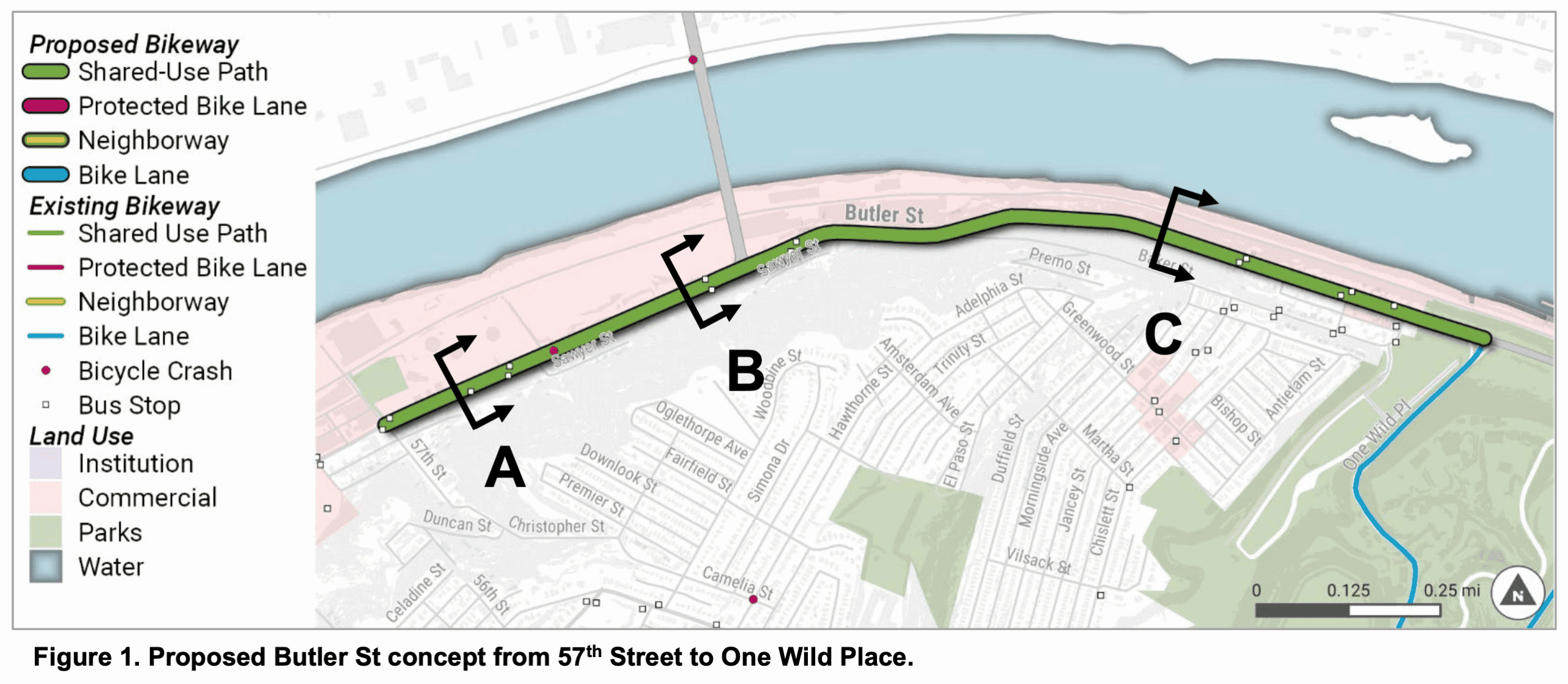
While not a full closure, there’s been so many construction closures on the upper part of Butler St that it makes it glaringly obvious that there is way more space dedicated to motor vehicles than necessary. This opens up an opportunity to make some important connections for bicyclists and pedestrians between Lawrenceville and Morningside. The City’s forthcoming Butler Street Project will create a shared-use path along Butler Street between 57th Street and One Wild Place (approximately 1.6 miles). This network improvement will essentially open up new ways for Lawrenceville residents to access the Pittsburgh Zoo & Aquarium and create new ways for East End residents to commute by bike and leave their car at home.
Others?
There are currently some other random road closures that with some creativity, could extend the bike network and help complete the City’s Bike(+) Plan. Herron Ave Bridge is closed, and there is a desire to better connect Polish Hill to the Strip District and Lawrenceville. Spring Garden’s closure highlights the potential of connecting Deutschtown to Reserve Township. The closure on Becks Run would offer new ways for residents to ride to the South Hills and even Mount Oliver.
Check out DOMI’s road closure map to see where construction permits will affect your travel.