Approximately half of motorists caught traveling above speed limit
Death and loss can inspire a range of reactions: anger, sadness, questioning, and, sometimes, a commitment to bringing about a change.
On his daily bike ride to and from Oakland, Bloomfield resident, Matt Bauman experienced a nagging concern about his safety along Forbes Avenue. But after Susan Hicks was struck and killed by a car while riding her bicycle on Forbes Avenue in late October, that feeling of concern was replaced by a sense of urgent need.
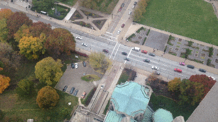
Without access to a radar gun or other sophisticated tools, Matt improvised. He trudged to the top of the Cathedral of Learning on Pitt’s campus and recorded 10 minutes of traffic on Forbes Avenue (at 3:15 on a Friday afternoon) on his cell phone. Using just the cell phone video, his computer, and open source software he was able to track the speeds of cars along Forbes Avenue.
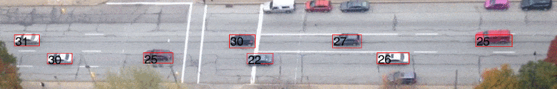
From there he was able to isolate the max speeds of the vehicles.
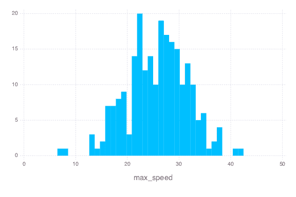
In just those 10 minutes, here are the maximum instantaneous speeds Matt saw:
Cars over 40mph: 2
Cars between 35-40mph: 12
Cars between 30-35mph: 49
So what’s the speed limit on Forbes Ave, you ask? 25 miles per hour. And here’s why: we live in a city and people are (expected to be) all over the damn place. Oakland is Pennsylvania’s third largest economic center (after Center City Philadelphia and Downtown Pittsburgh) and one of Pittsburgh’s most vibrant, bustling neighborhoods. Within just a 1 mile stretch, Forbes Ave carves through the center of both Pitt and Carnegie Mellon’s campuses.
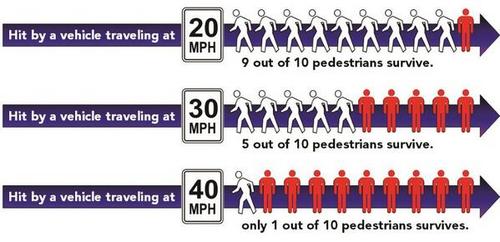
When cars are traveling at or attempting to reach speeds above 25 miles per hour they are much more likely to hit and kill pedestrians and bicyclists.
While we’re highly aware that more video should be shot and more data gathered this isn’t a statistically significant amount of information (edit: see comment by sgr below re: statistical significance of data), it’s a bit of proof of motorists speeding along Forbes that’s been gathered in an impressively scrappy way.
We will be working with Matt to gather more data in the coming weeks and will release it soon.
For more information about Matt, his methodology, and the change he hopes to see in in Oakland, read our short Q&A with this clever guy.
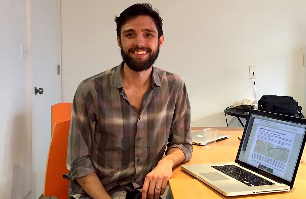
Matt Bauman is a PhD candidate in bioengineering at Pitt. ( i.e <—This isn’t even his field y’all.)
1. What prompted you to engage in this data collection?
I have bike commuted into Oakland all 5 years that I’ve lived in Pittsburgh and have often felt cars traveled too quickly given road conditions. Forbes has been a part of my commute for all of these years and so after Susan’s death I knew I wanted to help push for safer facilities. I got frustrated by the seeming pushback from Pitt and city officials on what they can do. They kept saying that their funding and ability to improve safety in the corridor was tied into BRT and was 1-2 years away at the earliest.
I felt that it was possible to slow speeds on Forbes Avenue now and knew that there have been conversations about calming traffic. But I had never seen proof that people were speeding, so I decided to investigate.
2. What was your methodology?
I don’t have a radar gun, but I thought that by taking a video of the street I’d be able to see cars and track how fast they were going.
I went to the top of the cathedral and propped up my phone and recorded 10 minutes of video of Forbes Avenue. I then did some basic processing to identify cars and each lane and then attach speeds.
The trickiest part was determining the scale for speed, but I solved that by measuring the distance between the wheels on the busses – a standard width – throughout the frame. By doing that I was about to get the space in real units.
3. How do you hope to help?
I think the first step in addressing a problem is identifying that there is a problem. The ability we have to collect this data is powerful and I hope to it will affect decision makers and policy makers.
4. What would a safer Fifth/Forbes mean to you?
It would mean a road that I could take home without worrying. Even if not dedicated space, lower speeds for car traffic. But dedicated lanes for bikes would be great.
5. Anything else to add?
I really find it incredible that we can gather this data ourselves. This is just a small proof of concept but I hope it can be taken and duplicated in Pittsburgh and elsewhere to make roads safer for everyone.
Also, this is not my field, it’s just something that I learned on the side. Experts will be able to take this on better than I can.
Take action for a safe Fifth/Forbes. There is an urgent need for safe spaces to bike in Oakland – the Fifth/Forbes corridor is deadly for cyclists. We need YOU to join our coalition to take action and help us transform the corridor.
10 Comments
Awesome job, Matt. Maybe the folks with the power to make us all safer will now have to pay attention.
This is AWESOME.
I must point out an error in the article:
“While we’re highly aware that this isn’t a statistically significant amount of information, it’s a bit of proof of motorists speeding along Forbes that’s been gathered in an impressively scrappy way.”
I disagree. This amount of data IS statistically significant. From an eyeball of the data, the mean will be 27+/-3 mph. The standard deviation is roughly 10 mph. Increased statistics will only decrease the error bars on those estimates.
Do not undersell this. The statistics are already meaningful for this day of the week and time of day, and show that very nearly half of drivers are traveling too fast.
Increased data collection will only increase the confidence and extend it to other days and times, which may be different.
To the graph, I would add a thin vertical line at 25 mph. Nice work!
Here’s a suggestion for your next project, Matt: Find a spot where you can observe a busy intersection in Oakland on a day when classes are in session and compare the number of people on bicycles who obey traffic laws (the same as for motor vehicles) with those who don’t. Please share the results with us. Thanks.
This is an interesting study. But is it that surprising? Bicycling, or even acting as a pedestrian, can be terrifying at times. Vehicles come to sudden stops, instead of gradually decelerating to the light. Red light runners are everywhere.
NO ONE drives the speed limit. Does anyone on this board? (I do, except on Bigelow Boulevard, but then people are always passing me there). I’d say that on Fifth Avenue in Oakland, a 35 mph habit is still safer than most other streets in the commercial corridors of the city! Try biking Fifth/Sixth/Diamond Streets downtown. It’s a madhouse, very dangerous, and there really is no reasonable way around it. Illegal stopping/parking (on the sidewalk), speeding, and sheer arrogance make it a dangerous mix.
[…] On his daily bike ride to and from Oakland, Bloomfield resident, Matt Bauman experienced a nagging concern about his safety along Forbes Avenue.Without access to a radar gun or other sophisticated tools, Matt improvised. Using just the cell phone video, his computer, and open source software he was able to track the speeds of cars along Forbes Avenue. More>> […]
[…] Bike Pittsburgh | Guerrilla style: Pitt grad student uses cell phone to track speeds on Forbes Ave i… […]
[…] that aims to change this by turning every smartphone into, well, a speed camera. Inspired by Matt Bauman’s guerrilla, open-source tech, Speed Camera’s spatial interface leads users through the process […]
[…] bicycle & pedestrian groups, Envision Downtown’s Public Space Public Life surveys, and smartphone-assisted speed monitoring on Forbes. Dovetailing with an official turn towards open data, City Planning organized the first city-wide […]
[…] “We live in a city and people are (expected to be) all over the damn place.” The speed limit in almost all of Lawrenceville, as in Oakland and most of the rest of the City’s surface streets, is 25 mph. Yet, the actual speeds driven in much of the city are much higher. […]